After extracting the text from the land area map all at once, it is recognized by automatically estimating the tilt. The surrounding line shapes do not affect the recognition results as they are on separate layers. Mistakenly recognized parts can also be easily corrected using mouse operations.
- Demo animation of cadastral map processing
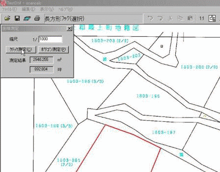
- Measurement of land area in cadastral maps GIF animation The measurement of polygon area is performed using the polyline to polygon conversion function of the raster editing library. From the area on the drawing based on the scale, it is converted to the actual area.
The recognition time for a land area map of A3 size and 400dpi is 2 seconds(Core2 Duo) to 5 seconds(Pentium-M) with 135 segments.
The polyline to polygon conversion takes only a moment.